
Titan Rocks is a challenging but rewarding Southland day hike, with expansive 360° views.
Length: 16km return with ~1,100m elevation gain
Time taken: 7-9hrs return
Difficulty: moderate
Facilities: Long drop toilet at Piano Flat campsite at the start of the track. Several streams cross the track where you are able to source water.
– Important: The track in the forest can be easy to lose, especially near the frequent tree-fall. The section above the bush-line is very steep tussock and would be extremely exposed in poor weather / poor visibility. –
Why Titan Rocks?
I was craving some outdoor time, and a bit of a physical challenge. I looked at my Southland hikes blog post to find a trip I hadn’t done before, and Titan Rocks was at the top of the list! It would certainly be a challenge based on my (poor) fitness level, but I was desperate to get out into the hills and willing to give it a go.
How to get to the trailhead
The track starts at Piano Flat campground, which is a two hour drive from Invercargill. The first campground isn’t the trailhead, keep driving to the next site with a turn-off on the left to a long drop toilet. You should be able to see the swing bridge over the Waikaia River, which is the start of the track to Titan Rocks.
Titan Rocks trip report / guide
The hike to Titan Rocks can be split into three parts (featuring my non-fit times, you might be a lot speedier!):
- The river track: 20-30 minutes
- Climbing in the bush: 2 hours
- Climbing up the tussock: 2 hours
- Descent: 3.5 hours
9 hours return (for me)
Note: my photos aren’t up to normal standard, I didn’t take my camera on this trip – just my phone. Hopefully they still give you a good idea of the track!
1. The River Track
The first section follows the Waikaia River Track for around two kilometres, on the other side of the river from the campground and road. Normally I love a good swing-bridge, but not this one. One-person limit, very tight (my bag and poles kept getting caught on the netting), and extremely swingy (as in, tipping side to side). Wouldn’t recommend if you have a serious fear of heights.


The Waikaia River Track, along with a lot of the surrounding area, was damaged by the 2020 floods. I thought the river track portion would be a Great Walk level track that would be easy to motor along. But in fact it’s more like a typical tramping track, with a few slips into the river to negotiate around.
I scouted the river on my way up, knowing I wouldn’t want to cross back over the bridge again (and wouldn’t mind skipping some of the slips). Around 200m upstream of the bridge was a good spot, although it was still over knee height and had a bit of flow when I crossed back again at the end of the day (in the middle of summer). I’d only recommend if you have river crossing experience and it’s at low flow.
After around 20-30 minutes walking, I reached the sign marking the turn-off to Titan Rocks.


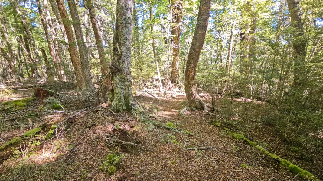
2. Climbing in the bush
The Titan Rocks track starts the way it means to continue; immediately uphill. The gradient isn’t too bad (a slope rather than climbing straight up tree roots), but it was definitely enough to get me puffing.


Initially the track was overgrown with ferns, and I regretted not wearing longer gaiters / pants – my legs got quite cut up! The ferns also meant the track was hard to see, I had to pay attention so I didn’t lose it.
Eventually the ferns gave way to more open track, but then the next obstacle arrived – tree-fall. Most of the tree-fall is old and there are worn paths around so you don’t have to clamber over it. However, it’s easy to lose the track on the other side of the fallen log.
Even on the rest of the track, it can be easy to lose your way if you’re distracted. The orange markers are quite widely spaced and not always easily visible. I lost my way once on the way up and once on the way back down. It was easy to find the track again, but a bit spooky being solo!


Stream crossings
After climbing around 300m elevation, I started to descend to the first of two streams. I filled up my filter bottle here, not knowing if I’d cross another water source (spoiler: I did). I managed to cross the first stream with dry feet, but the second stream involved crossing a knee-deep hole, so wet boots from here on.

From the second stream it was a steeper climb up. I could hear voices above me and I soon caught up to the couple of ladies from Riverton who’d been leapfrogging me from the carpark.
The clearings
At the first tussock covered clearing we made the mistake of continuing into the tussocks (ignoring the sign pointing to our left that said: “Titan Rocks 2 hours”). We had to double back and find the track again, which was immediately to the left of the sign, of course!


From there it was a slow climb up through less overgrown forest. We passed through three more clearings from which we could see the tussock climb ahead of us. Something inside me whimpered. The tussock section looked steep, exposed fully to the sun, and higher than I’d expected. We passed the time until the treeline discussing whether or not we’d turn back, or carry on up the tussocks.

We climbed slightly more steeply uphill and crossed a small stream, where I once again refilled my filter bottle (I imagine it might run dry during a hot, dry summer). Then finally we reached the treeline!
3. Climbing up the tussock to Titan Rocks
At the edge of the trees I said farewell to my new friends, who continued on up while I rested in the last bit of shade and reapplied sunscreen. The two ladies climbed the rocks directly above where the track exits the trees, while I followed the poled route around to the left / south. I waved goodbye as they reached the top of the rocks and then they disappeared from sight as I continued to climb up the route.


I crossed a stream where I refilled my other water bottle, anticipating a long, hot, exposed climb ahead of me. And that’s exactly what it was. Quite steep (not scary steep, but enough that I was only clambering 10m uphill before having to take a quick break). There was no worn track, just tussocks to negotiate around between poles (which once again were very widely spaced – they’d be very easy to lose in poor visibility).

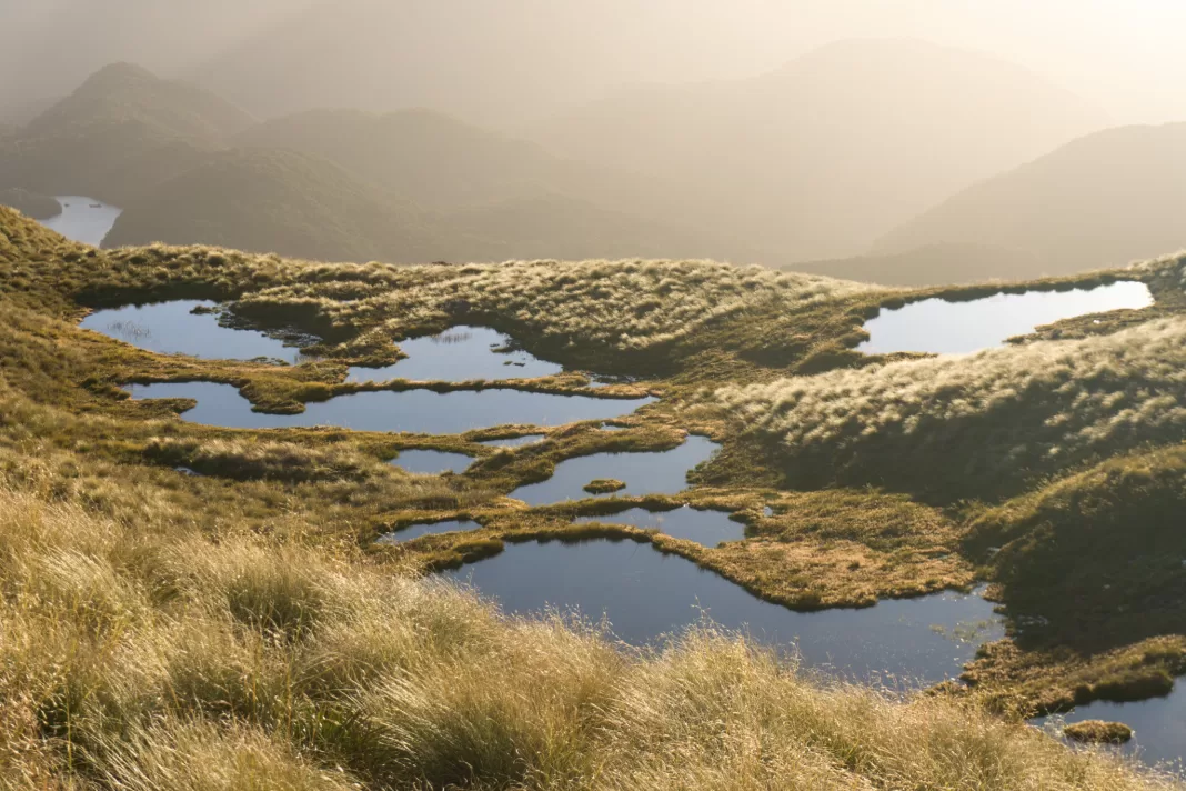
Reaching the plateau
After what felt like foreeeeeeever, I finally topped out onto the edge of a giant tussocked plateau. Ahead of me stretched an entire kilometre of flat land, which also reached 1.5km to my right and 500m to my left. After walking uphill for almost 5 hours, it felt surreal to reach such a flat space at the top of the climb!
I made the mistake of climbing the rock stack right next to where the track reached the plateau, but at the top realised my mistake. Titan Rocks were 500m away on the edge of the plateau looking towards Waikaia. I had to down-climb, walk around the rocks and then walk 10 minutes through boggy tussock before I was finally at my destination.


Titan Rocks
I climbed up to the top of Titan Rocks and took in the view while eating a well-earned chocolate muffin. I had patchy cell service at the top, so I text my partner an update rather than using my Zoleo (satellite device). I’d finally reached the rocks!
There were 360° views everywhere I looked. I peered down at Piano Flat where I’d started so many hours ago, looking very distant, then followed the Wakaia River south, towards the Hokonui Hills. To the east were the Umbrella Mountains, sitting at a similar height to Titan Rocks. To the west lay wild tussock slopes eventually ending in the Garvie Mountains. And to the north, stretched what seemed like endless tussocked plateaus and peaks, all the way towards the Old Man Range and Alexandra.
As much as I would have liked to spend a long time relaxing and soaking in the surrounds, I felt the pressure to turn back. I was already 30 minutes past my planned turn-around time. And I had a long way to climb down before the dreaded drive back to Invercargill.

4. The Descent
Making it to the top was only half the trip, so before I was quite ready, I climbed back down Titan Rocks to lope back across the plateau. Climbing down the steep tussocks on tired legs was pretty soul-destroying.
I took a more direct approach than the poled route I’d climbed up, choosing to aim for the rocky outcrop halfway down that my new friends had made it to. There were beautiful views from the top, but it was a very steep scramble down, most of which was sliding on my bum (poor shorts). I wouldn’t necessarily recommend this way!

After what felt like an eternity, I finally made it to the bushline.
The rest of the climb down passed quickly. I didn’t meet anyone else, and only lost the track once more. My thoughts and an audiobook in one ear kept me company.
It was a relief to reach the sign to Titan Rocks back on the river track. I crossed the Waikaia River just a little upstream of the swing-bridge, at the spot I’d scouted out earlier that day. It was then easy walking on the other side of the river through the campsite to the carpark.

The two lovely ladies had left me a note cheering me on which was so nice to receive! I’d rinsed myself in the river, so I changed into fresh clothes, had some very warm water from the drink bottle I’d left in the car, then set off to reward myself with takeaways in Gore.
Final thoughts on Titan Rocks
Titan Rocks was certainly a test of my fitness. I’d almost bitten off more than I could chew. But it was a great kickstart to my summer! As I drove back down the gravel road, golden light highlighting the hills, blasting music with the windows down, I couldn’t keep from glancing in my mirrors to see the top of Titan Rocks. It looked impressive. I turned my eyes back to the road and a long drive ahead, a satisfied smile lighting my tired face.

Where should you explore next?
Safety
As always, please stay safe when you’re out exploring. Follow the Outdoor Safety Code:
- Choose the right trip for you (read my article on tramping safety, talk to DOC)
- Understand the weather (this can be a pretty exposed trip above the treeline in bad weather, and in winter the track under the trees barely sees the sun so gets very icy)
- Pack warm clothes and extra food (check out my post here about what gear you need to take)
- Share your plans and take ways to get help (have an emergency beacon on your person)
- Take care of yourself and each other
If you’re not feeling super confident then you can always get in touch with me here on the blog or on my Instagram. Or take a look at my Tramping 101 series which includes this post about how to stay safe in the outdoors.
Also don’t be a dick, check out my guide to New Zealand tramping etiquette.
Stay safe and get outside!