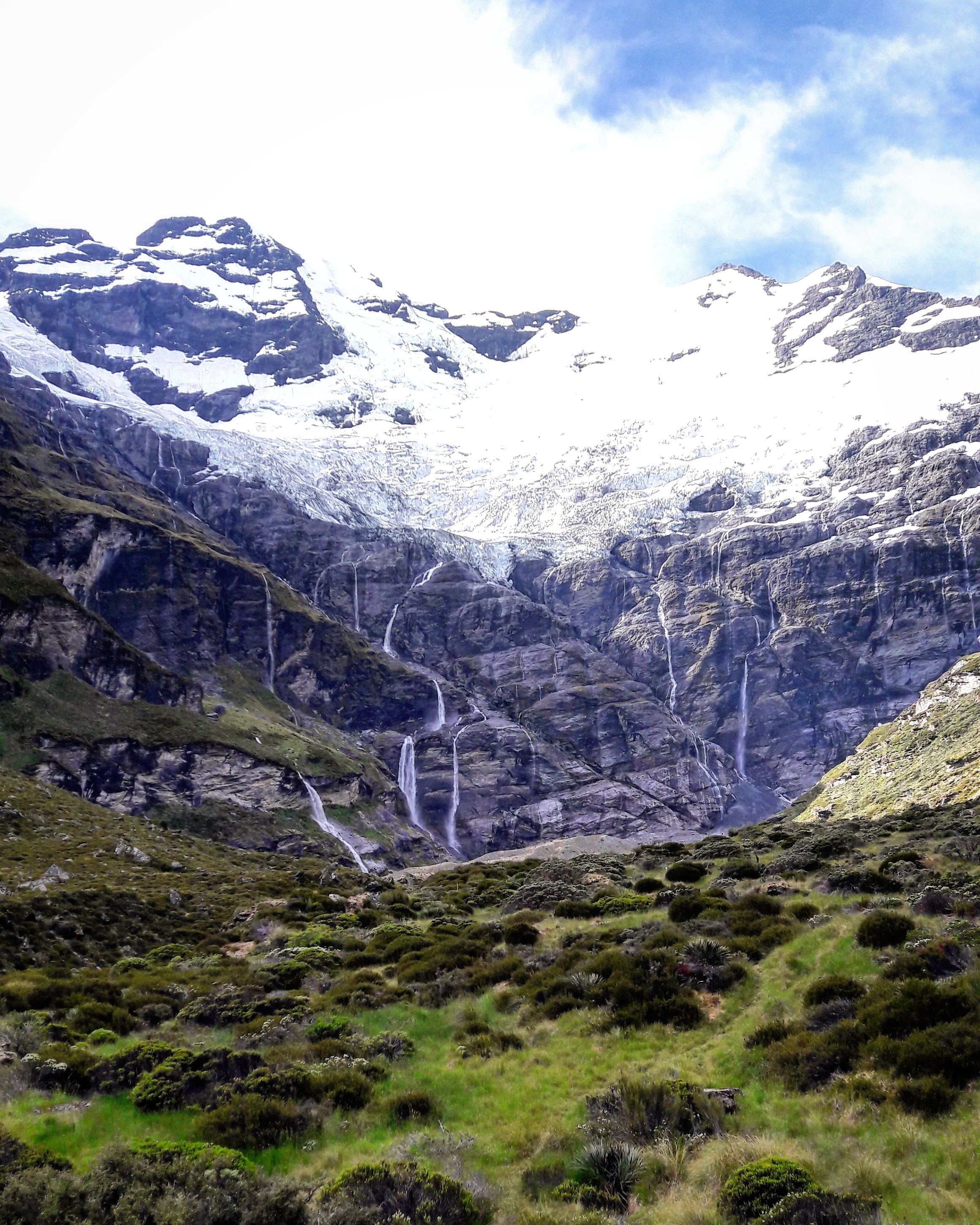
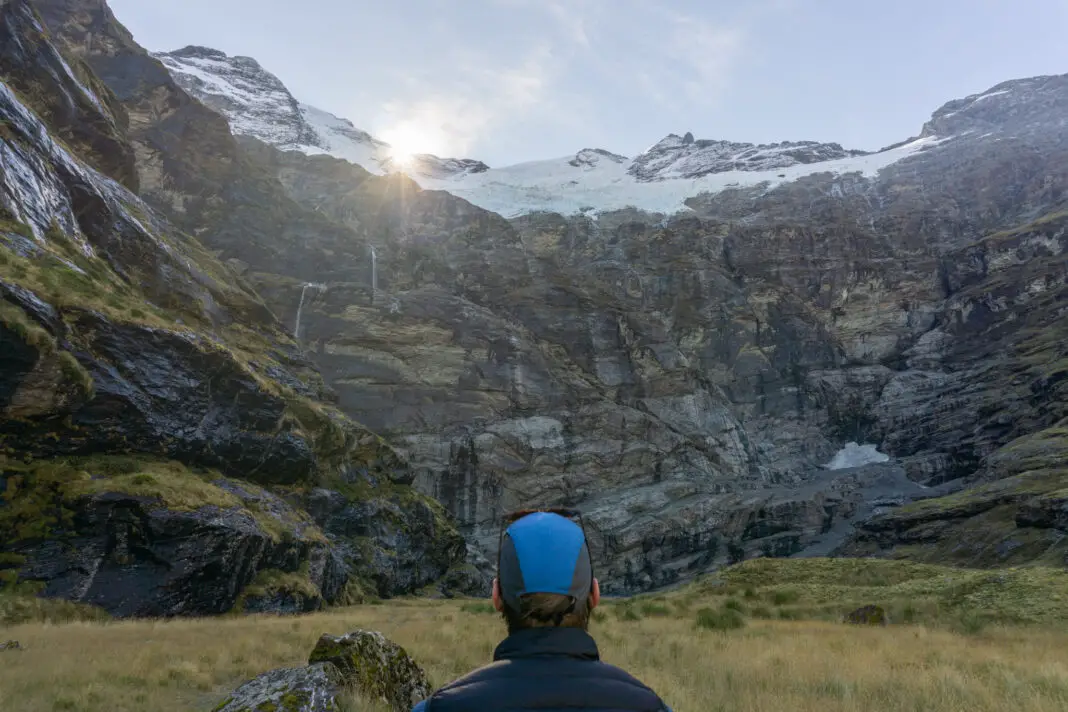
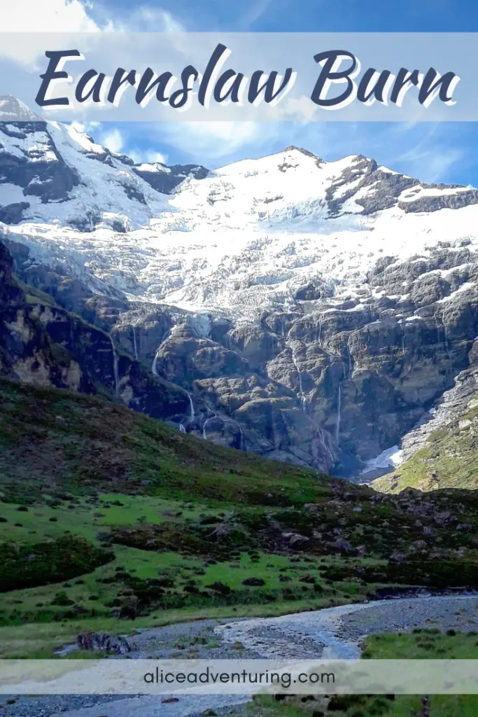
This is an absolutely amazing trip. Follow the Earnslaw Burn through lush forest to a tussock-covered valley with jaw-dropping views of the hanging glacier and waterfalls on Mt Earnslaw.
Length: 9km to tree-line, then another 5km to the very head of the valley.
Time taken: Overnight tramp, 6-8 hours each day with packs.
Difficulty: You need basic route-finding skills. I wouldn’t recommend doing this in winter / bad weather unless you have the necessary experience.
Facilities: No toilets or accomodation. Fresh water readily available from streams.
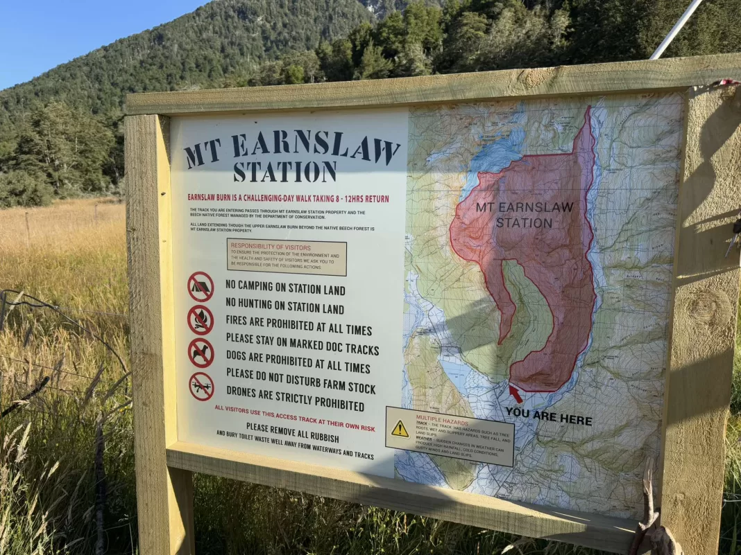
Note: The track through the forest is mostly on public conservation land (other than small sections at the start). However once you reach the tree-line, the open valley is private land with a public easement 10m either side of Earnslaw Burn (the river). Camping is not permitted on station land.
Why Earnslaw Burn?
Earnslaw Burn popped up on my radar while searching for a ceremony location for our wedding. Although we ended up going with a different location, images of the stunning hanging glacier stayed seared into the back of my mind.
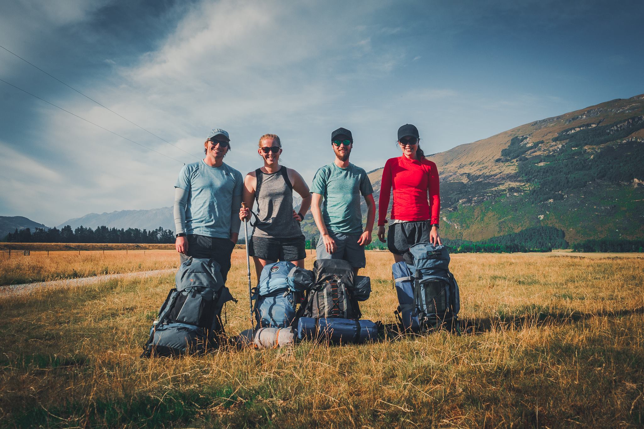
So four years ago, I convinced my husband Matt, and our friends Codie and Georgiana to hike up the valley to see this view with our own eyes. Earnslaw Burn wasn’t too popular at the time (although this has since changed). We had the valley basically to ourselves on a summer weekend, crazy!
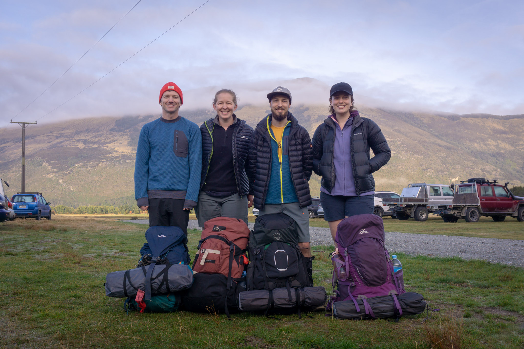
However, on that first trip we didn’t made it to the very head of the valley. It stayed with me – that view haunting my imagination. So four years later, we organised an Easter mission – two nights camping with ample time to explore all the way up to the head of the valley and the waterfalls. Nothing could go wrong, right?
How to find the trailhead for Earnslaw Burn
The Earnslaw Burn track starts from Lover’s Leap Road past Glenorchy, just over an hour’s drive from Queenstown. There’s no real signage or great cell service at the carpark so make sure you pop “Earnslaw Burn Track Parking” into Google maps before leaving Glenorchy so you don’t miss the turn-off. It’s about a 10-15 minute drive from Glenorchy.
Once on Lover’s Leap Road it’s normally pretty obvious where the trailhead is (normally lots of cars). But if there aren’t many vehicles parked, the track starts off the first right-angle corner of Lover’s Leap Road.
Hop over the padlocked gate on the right (not the one leading down to the river, the flat paddock one). Remember to always climb over gates at the hinge-end, unless you want the ghosts of countless farmers to come after you. Then follow the fenceline to the trees where there is a DOC sign marking the start of the track.
If you’re looking for beautiful hikes near Queenstown, check out these trips:
Valley of the Trolls
The beautiful Valley of the Trolls might be one of my favourite places in the country! It is well worth the hidden detour off the busy Routeburn Track.
Cascade Saddle Route
This is an adrenaline-inducing challenge in Mt Aspiring National Park with sheer drop-offs and incredible views of the Matukituki Valley, Dart Glacier and Tititea / Mt Aspiring.
Tramping the Earnslaw Burn Track
When I first tramped the Earnslaw Burn track, it wasn’t actually a track at all. And I wasn’t very fit, having spent the better part of my Masters degree eating my weight in M&Ms. But what a difference four years makes! This second trip saw me at the the fittest I’d ever been since high school, having spent a summer completing my bucket-list of hikes. And the “route” which had been full of tree-fall, had turned into a track with most of the fallen trees chainsawed up. Quelle luxe!
The first hour of the tramp starts off climbing steadily uphill through beach forest and meadows, leaving the river below. There are consistent orange markers on the trees to help find your way, and the track is relatively well-formed, although be careful to not follow one of the many animal paths. Almost half of the day’s climb is actually done in this first section, and if you’re carrying a pack you certainly feel it!
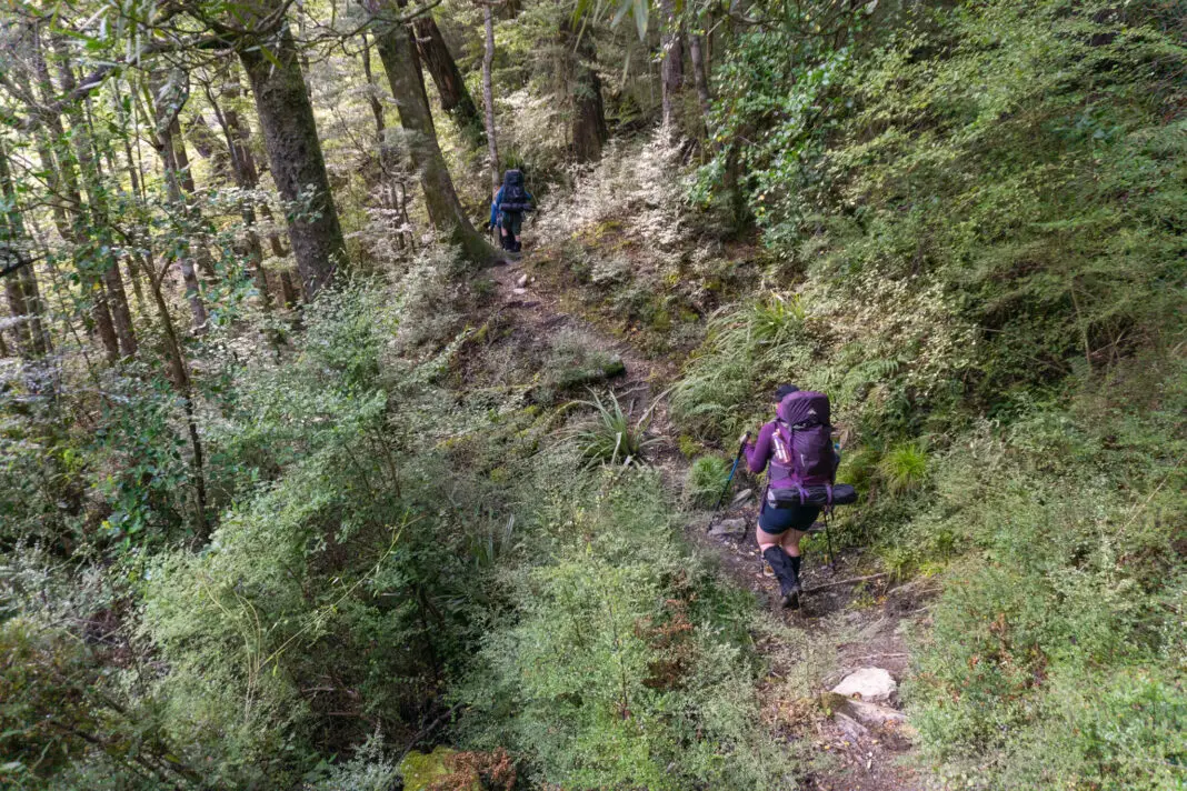
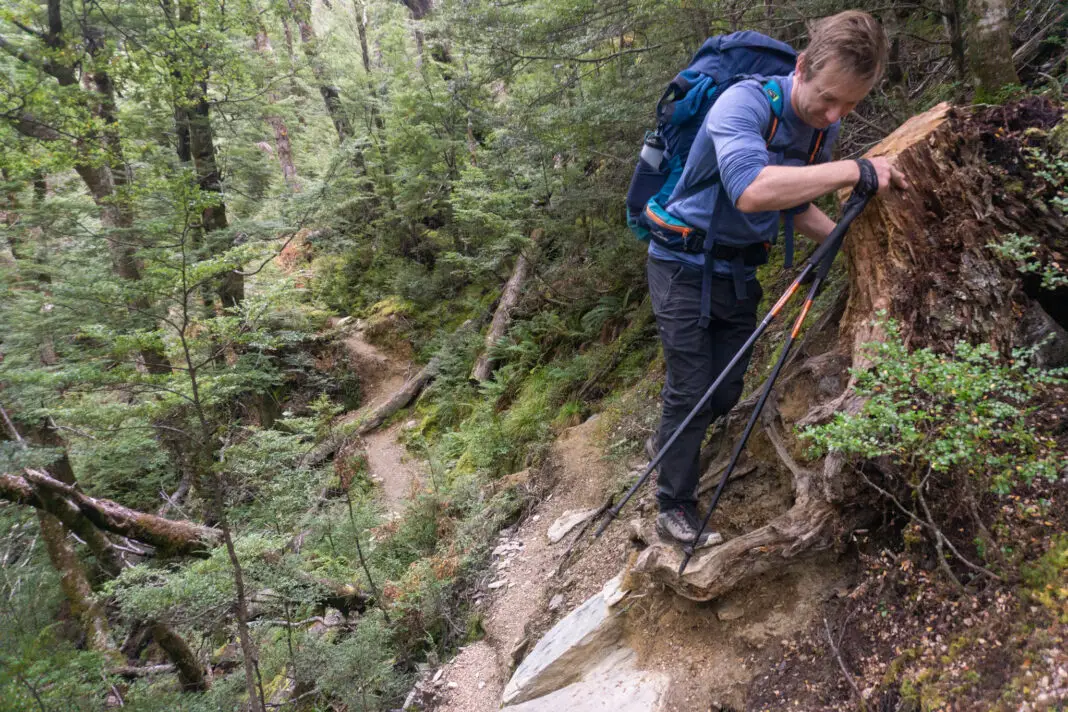
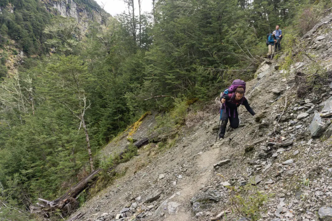
The next hours before reaching the treeline are deceptive and seemingly never-ending. Although the track isn’t as consistently steep, there are plenty of short and sweet inclines, as well as lots of big steps to keep your muscles working.
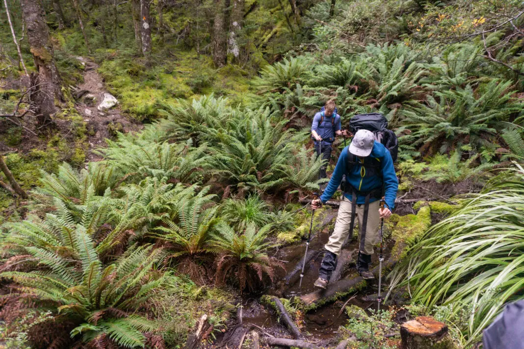
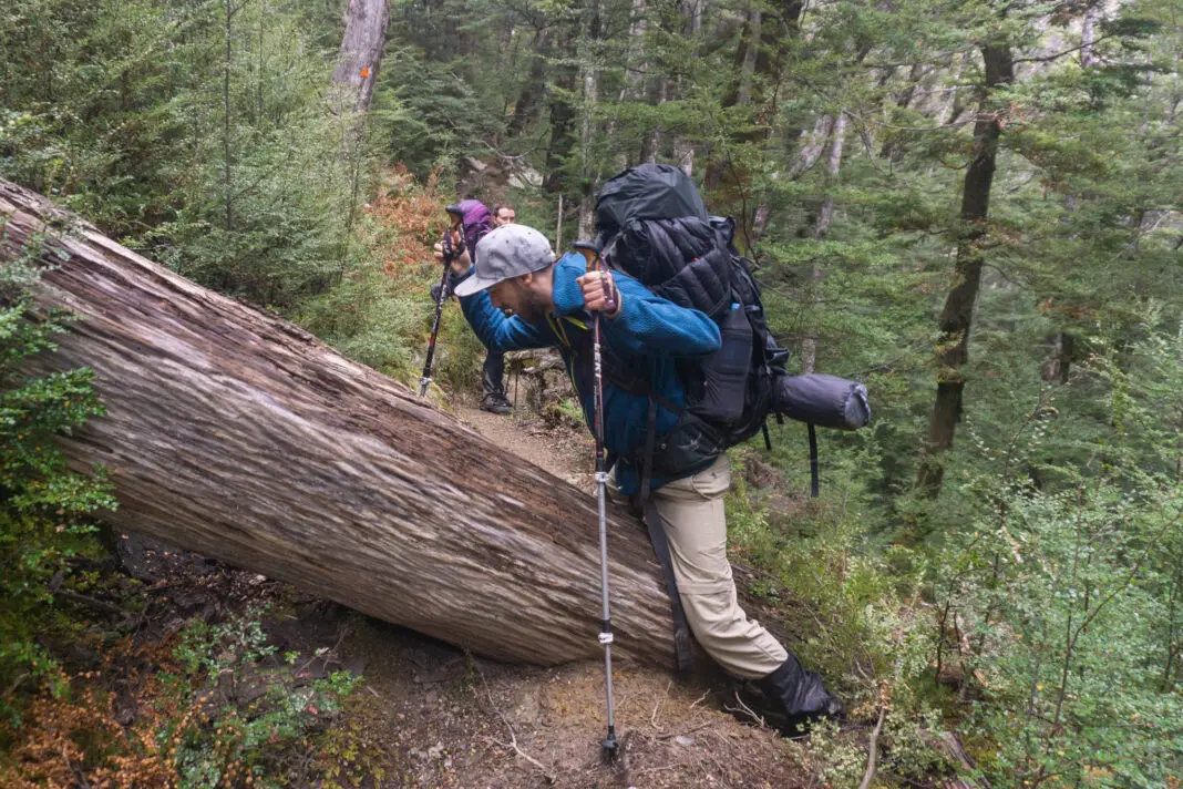
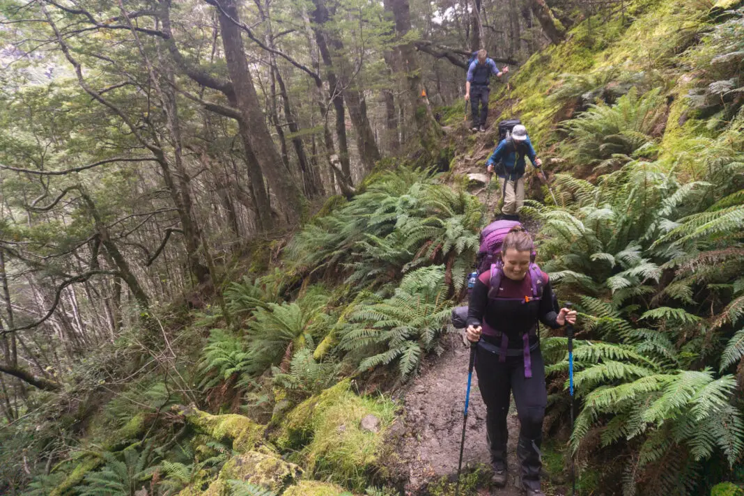
We tramped along the side of the valley, up and over small ridges, splashing through small streams (thank you waterproof boots!), tripping over tree roots for what seemed like forever. There were a few sketchier parts across slips or climbing up / down steep tree root sections, but nothing too crazy.
On the first trip I tried (and failed) to count the streams on the topo map. It led me to thinking we were a lot closer to the end than we were. Tears, tantrums, heartbreak and rifts in friendship ensued. In short, I wouldn’t recommend.
What I WOULD recommend is downloading a topomap app with GPS. This, and my increased experience with route finding, helped us know where exactly we were on the second trip, which in turn helped keep our expectations more realistic.
The treeline
It took us a total of six hours (including breaks) to get to the treeline carrying our packs. (Although we started looking for clearings around every corner from the 4hr mark onwards, since we’re optimistic people). In the end the best marker that you’re getting close to the treeline is that you’ll notice the river slowly rising to meet the track / route. You’ll cross the largest stream by far (really a wide-open gravel riverbed, evidence of what you’d have to tackle if you came through after heavy rain). From there it’s about 20-30 minutes to the edge of the trees.
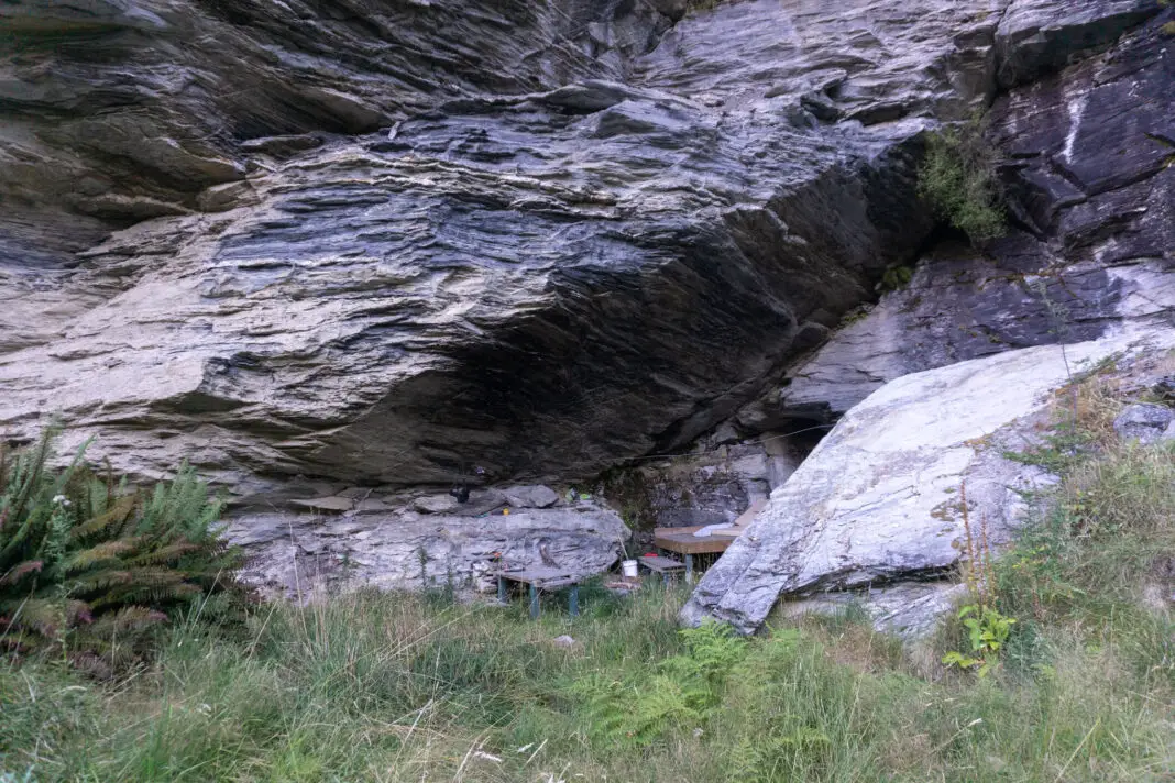
There is a bivvy rock on the other side of the river (true right) just before you leave the cover of the trees. This rock bivvy is on public conservation land and as such you can wild camp here, so long as you follow Leave No Trace.
There are some cairns marking the bivy’s location on the other river bank. It’s pretty massive, decked out with a sleeping platform and a few old mattresses. It would be great shelter in wet weather, but obviously does require a river crossing. If you’re planning on lighting a fire, make sure to check the fire ban, as conditions in Central Otago are often tinder dry.
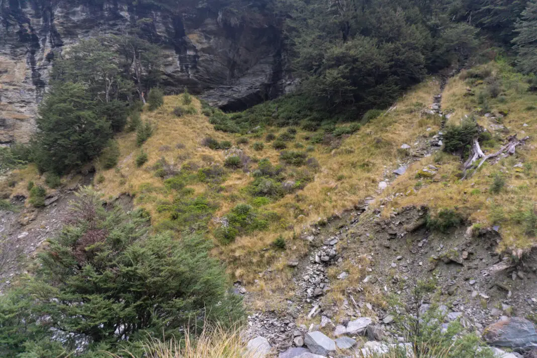
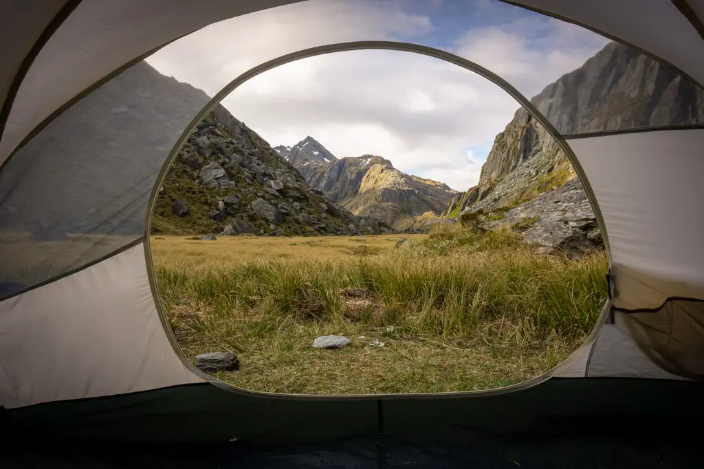
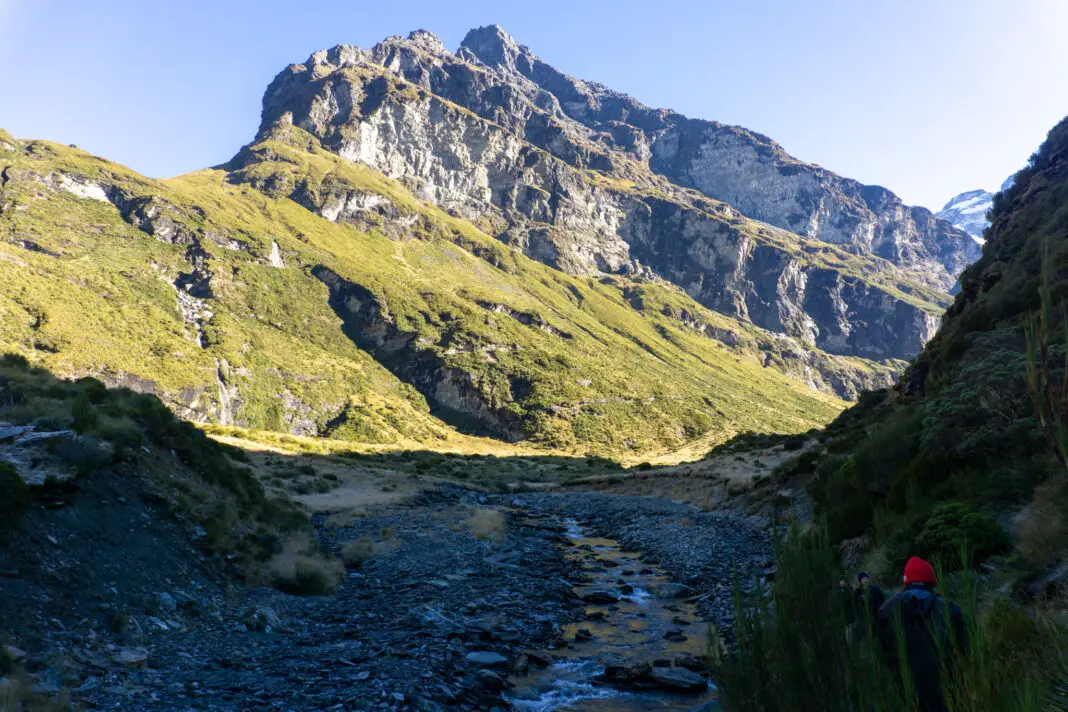
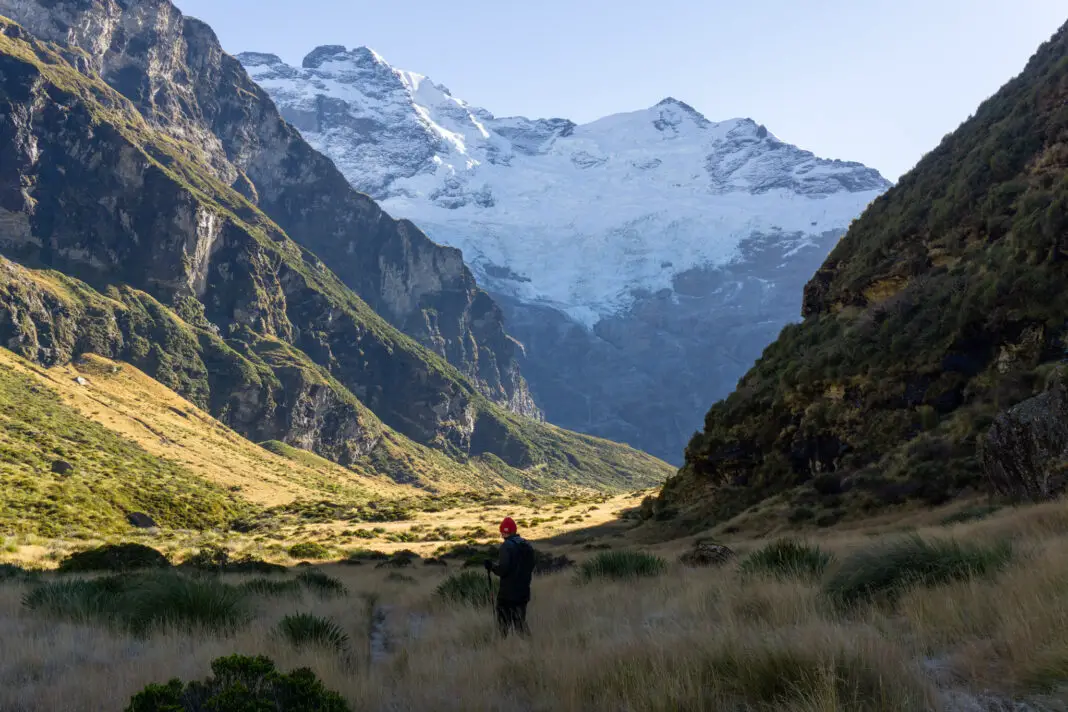
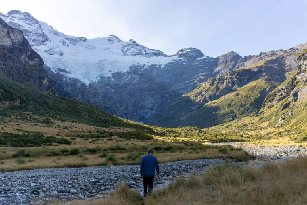
The Earnslaw Burn Valley
Past the treeline the track degenerates a little, but you’d still have to really try to get lost. Keep heading up the valley with the river on your left and the hills on your right. Just beware the spaniards! (Not Spanish people, the spiky grass). They are prolific in parts of the valley and like making friends. I would highly recommend wearing gaiters, unless you like bleeding profusely from tiny holes all over your legs.
The river is never too far from the track at this point. On our first trip we gathered drinking water directly from it. There were only two groups of trampers sharing the valley with us, on a beautiful summer weekend. But on our recent trip I was much more cautious, despite how crystal clear the water looked.
The four years between our two trips had seen a drastic increase in the number of people visiting Earnslaw Burn. I knew that hundreds of people had camped upstream with no toilet facilities just in the past few months. So as a precaution we mostly gathered water from side streams instead. Please follow the Leave No Trace principles to minimise your impact.
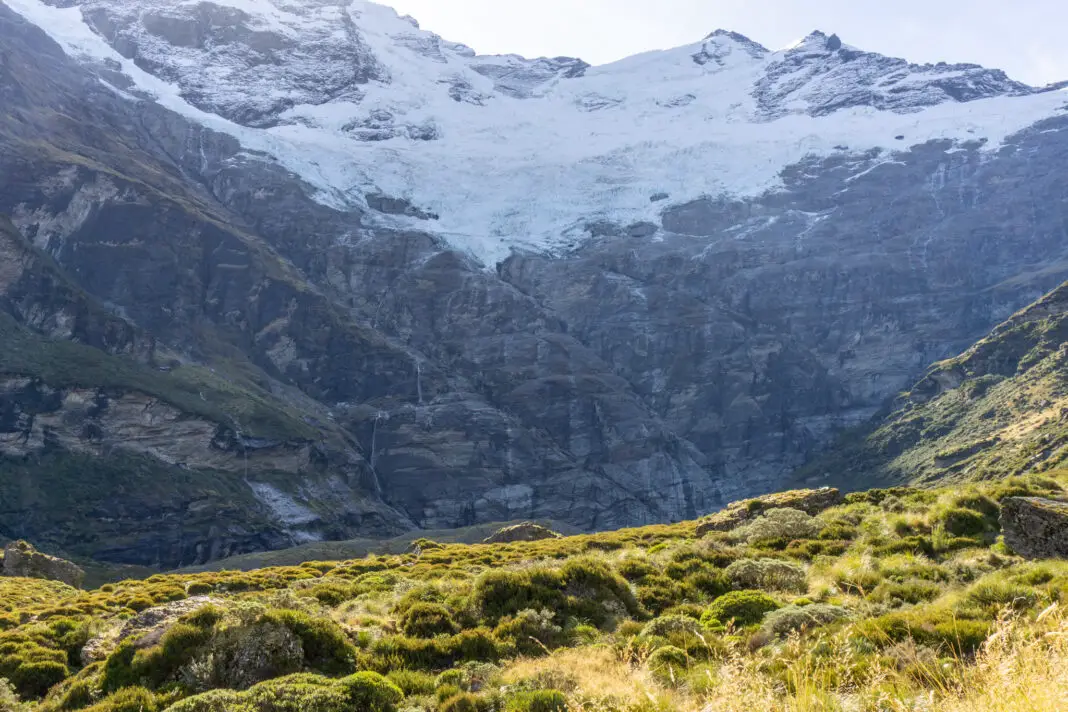
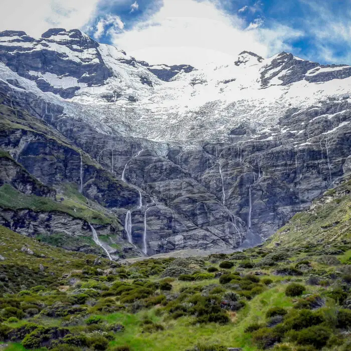
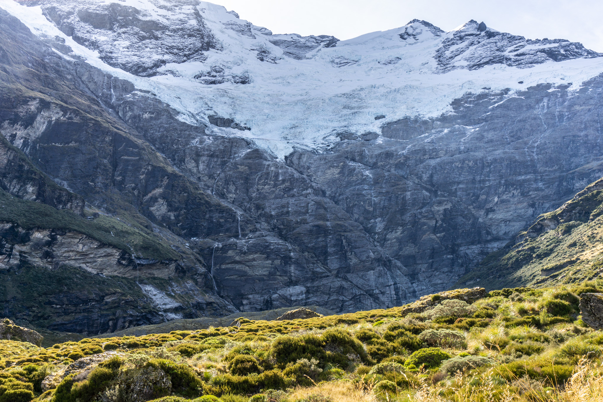
There is a narrow part just past the treeline that can be quite slippery. But once past this section, the valley opens up again, with beautiful views up towards the hanging glacier on Mt Earnslaw.
The head of the valley
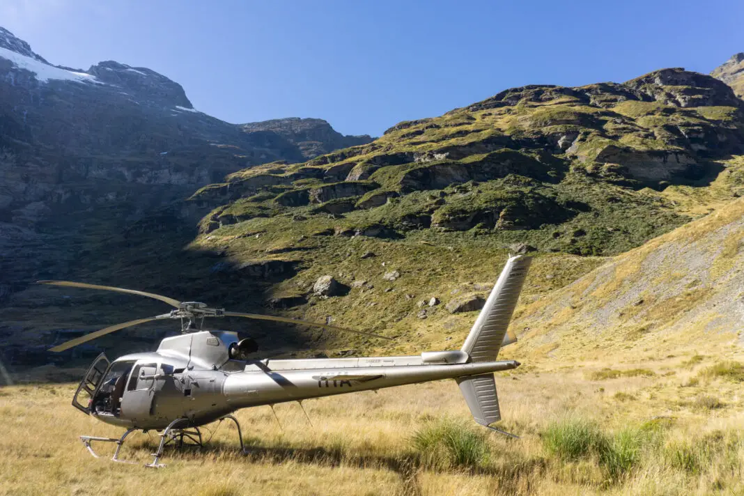
On our first trip, we only made it about halfway up the valley (which in retrospect is the spot that has the most expansive views). Helicopters flew over us as we walked; the valley is sadly not part of a National Park so the helicopter companies don’t need a permit to land. When I researched this trip back in 2018, I’d noticed that the Earnslaw Burn geotag on Instagram was half sweaty hikers and half impeccably dressed tourists.
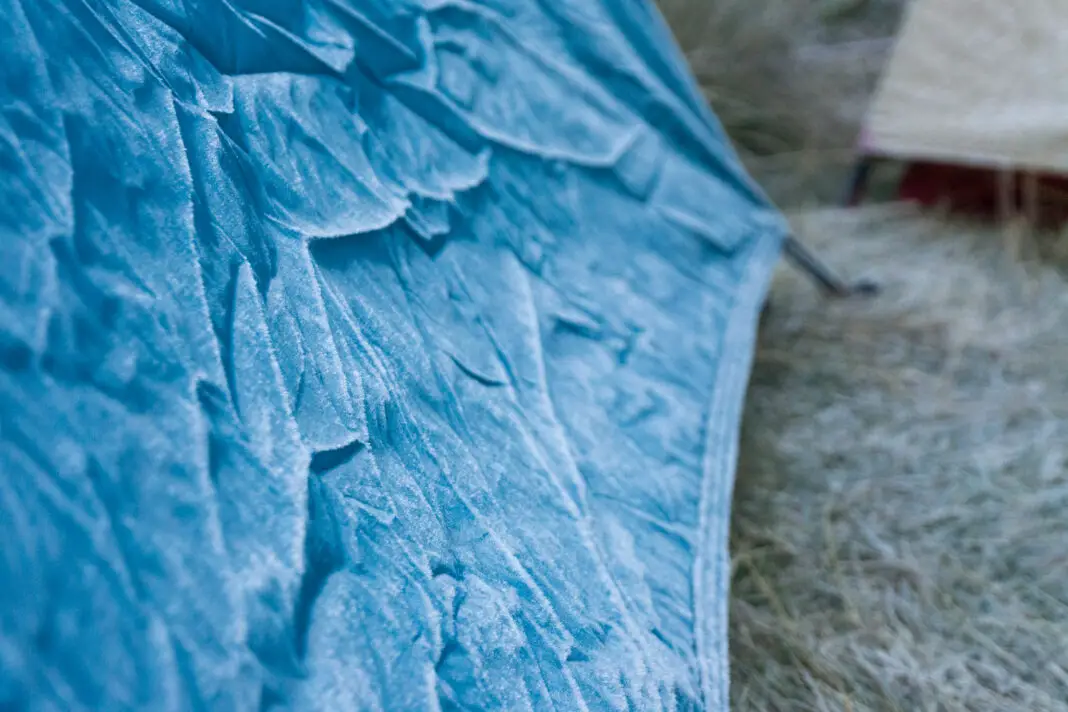
On our second trip, we had the luxury of an entire day to explore the valley. We woke to a beautiful sunrise and … frozen tents. I’d had ample time to contemplate the many differences between tenting in summer versus tenting in autumn while I was shivering in my sleeping bag all night. I swear we could have taken the poles out of Codie and G’s tent and it would have remained standing.
Our water bottles outside the tent had frozen solid, and poor Matt’s shoes, which had been soaked by the river crossing to the bivvy the afternoon before, were also frozen solid. We had to pour boiling water over them so he could actually put them back on.
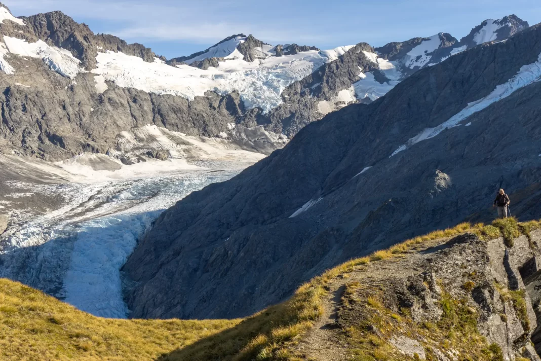
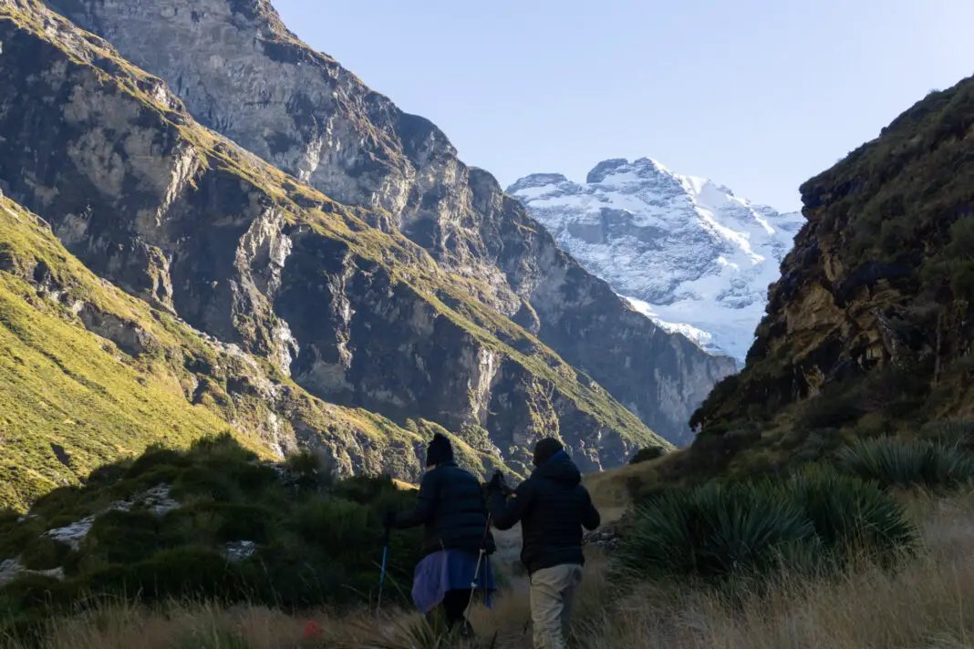
Once we were moving we warmed up quickly. The track was more well-defined from the increased foot traffic over the past few years, so we made better time and reached the head of the valley in a couple of hours (including breaks).
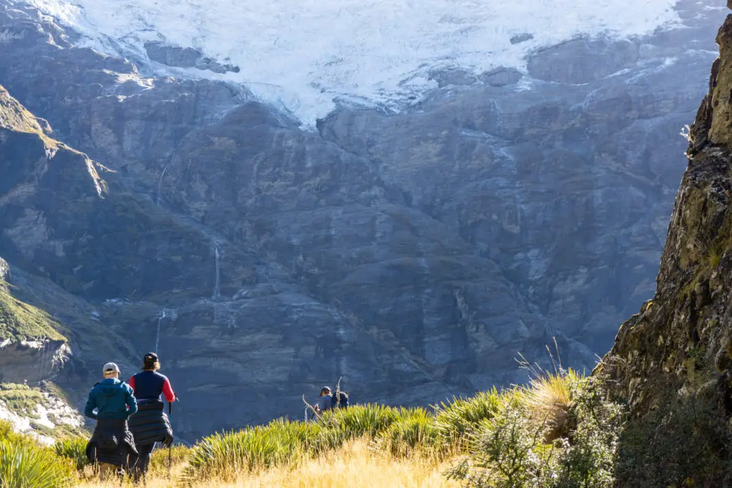
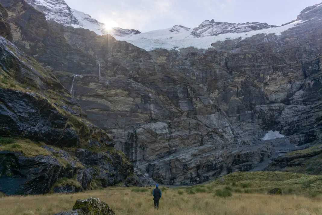
The views were still ridiculously amazing, but we were slightly disappointed to find that many of the smaller waterfalls had frozen and the larger ones had almost dried up. Something I probably should have expected, given the summer drought and how late in the season it was. At this time of the year the sunlight was also trickier for photos, with the sun quite low in the sky. The valley was extremely gorgeous and we had an amazing time. But I’d recommend going in summer, rather than autumn, if your main goal is photography.
And back again …
We stayed another night, this time not quite as frozen. We even had a doe visit us!
The way back out always goes a lot faster than the way in, even with stiff muscles. I mentally thanked the person with the chainsaw every time we didn’t have to climb over massive logs. It was a lot easier than our first trip, although the amount of tree-fall varies depending on what time of year you visit.
Leave No Trace
Earnslaw Burn is a beautiful backcountry valley that we all have a responsibility to protect. It’s only become more popular since I’ve written this blog post – this is actually the most visited page on my entire website. Sadly with the increased foot traffic and lack of toilet facilities, comes a lot of human waste. Please respect the private land if you are camping (the open valley past the treeline, with an easement 10m either side of the river) and practice Leave No Trace principles to reduce your impact on this beautiful location.
I imagine at some point, something will have to be done to manage this area – either the land owner will assert their right of privacy, or DOC will have to intervene. But at this point it is up to us as individuals to do the right thing and protect this beautiful environment for future generations.
… and they have done so. As of the start of 2025, new signs have been installed clarifying where camping is and isn’t allowed. Thanks Samsu Kim for supplying this photo.
All up, Earnslaw Burn is an absolutely amazing spot. I would highly recommend a trip! Feel free to chat with me by commenting below or messaging me over on Instagram. I love talking with people about tramping so don’t be shy!
Safety
As always, please stay safe when you’re out exploring. Follow the Outdoor Safety Code:
- Choose the right trip for you (read the blog, read other blogs! Read my post about how to stay safe)
- Understand the weather conditions
- Pack warm clothes and extra food
- Share your plans and take ways to get help
- Take care of yourself and each other
I went on this trip to Earnslaw Burn in summer and autumn with good weather – keep this in mind when planning your own trip as adverse conditions (even in summer) will mean a much different adventure! The head of the Earnslaw Burn valley, like many others in this terrain, has high avalanche risk in winter, spring and often into early summer.
Stay safe and get outside!
Where to next?
LET ME KNOW WHAT YOU THINK! LEAVE ME A COMMENT OR MESSAGE ME OVER ON MY INSTAGRAM.
I love hearing from readers and helping them plan their own adventures!
Fantastic read, I’ll be adding this hike to my list! Can’t wait to get out and see more of NZ!
Thanks Grace!! Can’t wait to go on another tramping adventure with you!
Good read. I know my family and friends are going to nz soonand can definitely tell them to go to these places 😊
Awesome! If you’ve got any questions or need any other suggestions for the South Island, don’t hesitate to get in contact! 🙂
Hey, thanks for this write-up! You mentioned the old topo-map had you starting on the wrong side of the river. So does the DOC map look correct to you? https://www.doc.govt.nz/map/index.html?banner=0&layerlist=0&base=Topo&layers=Campsites,Huts,Walking%20and%20Tramping&extent=1144860.333835564,4947267.695454749,2193,9&search=Walking%20and%20Tramping:477a1773-f410-4ade-8a0f-b3497d9c7191
Hi Andrew! The DOC map is correct once you’ve zoomed in enough (so the route is marked as starting and continuing on the true left of the river), but if you’re zoomed out it looks as though it starts on the true right bank which isn’t correct. Does that make sense? If you zoom in and out you’ll see what I mean I think, but yes – DOC map is correct once fully zoomed in.
Alice
Yes, makes total sense, thanks so much!
No worries Andrew, hope you have a great trip!
Thanks again. One for the adults I think.
Yes this route is a bit trickier, but still a fun adventure for the right set of older kids! Hope you get to see this valley some day soon Stephanie
Do you think you could do this track in a day? (Return)
Kia ora Petria! I definitely couldn’t do this in a day (I’m too slow), but I’ve seen some fit people do it in one day. They weren’t able to go all the way up the valley though, and had to turn around once they’d had the first real views. If you have time, I would highly recommend camping as you don’t want to feel rushed when the views are that beautiful. But if you only have one day and are very fit (and used to travelling over rough terrain!) then it is definitely possible – just keep an eye on the weather, the time and have a designated turn around time.
The problem is you are on private land, taking a dump wherever you feel like and tarnishing someone’s land have some respect you CANNOT CAMP HERE IT IS PRIVATE PROPERTY
Kia ora Angry, thanks for your comment, although not for the tone. I understand this is an emotive subject – the degradation of natural places due to human influence – and I understand that social media and blogs like mine have a role to play in this, although I don’t think simply taking this post down will serve any purpose as people will continue to flock to Earnslaw Burn.
I did not realise that the valley was private land, although I should have! I appreciate your correction, thank you, and have changed my post to reflect that, including taking down photos of camping further up the valley. It’s a good reminder to do more research before trips where I’ll be wild camping as I want to do so responsibly. I’ve also added more information on Leave No Trace principles and our responsibility to protect special places like this. I love the backcountry of Aotearoa and do not want it to be destroyed, let alone play a part in its destruction. My aim is to help people experience these beautiful places, but to do so in a sustainable way, so if you have any further suggestions, I’d welcome a cordial discussion. Thanks, Alice